Geography Class 30
Brief Discussion of Previous Class (5:09 PM)

Siberian Type (5:15 PM)
- This is also called cool temperate continental

- Summers are hotter, and winters are extremely cold and dry.
- This results in anti-cyclonic circulations.
- The rainfall is through the convection in summer, and through the snowfall in winter
- Vegetation is coniferous and is in the single largest stretch of vegetation on the earth.
- It is low in biodiversity but high in economic value.
- It is the only climate that is exclusively present in the northern hemisphere.
- Regions: Siberia, Russia, Poland, Scandinavia, Canada, Alaska
British Climate(5:30 PM)
- Cool Temperate Western Margin

- They are under the influence of Offshore westerlies, throughout the year.
- This causes precipitation which is moderate throughout the year.
- They are under the influence of warm ocean currents, which keep their ports ice-free even during winter.
- It is known for its characteristic mild winter and cool summer.
- Vegetation is a mixed type, i.e. mixture of broad-leaf and coniferous.
- Regions: United Kingdom, Norway, the western coast of Western Europe, Western Canada, Southern Chile, New Zealand, and Tasmania.
Polar type of Climate (5:40 PM)
- It is also known as the Tundra type of Climate.
- It is covered with ice throughout the year.
- During summers when the snow melts, vegetation grows stunted, like mosses, sedges, and lichens.
- The rest of the region is covered with permafrost.
- Regions: Any region beyond the Arctic and Antarctic circles.
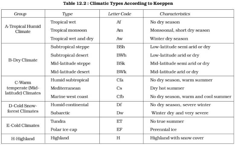
Koeppen Classification
Oceanography (6:03 PM)
- Ocean bottom Topography
- Ocean temperature
- Salinity
- Ocean Deposits
- Coral reefs
- Oceanic Currents and Circulations
- El Nino and related phenomena
- Tides
Ocean Bottom Topography (6:24 PM)
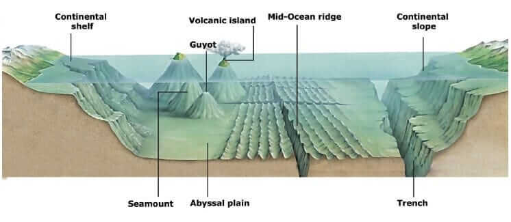
- Continental shelf
- (a) These are submerged shallow portions of the continental crust with depths between 150-200 m
- (b) It is rich in sunlight, oxygen, and nutrients, which favours the growth of plankton.
- (c) The width of the continental shelf is dependent upon the slope of the adjacent land.
- (d) It is wider along the coastal plain, and narrow along the mountainous coast.
- (e) The continental shelf is rich in biodiversity and is known for its rich fishing grounds.
- Continental Slope
- (a) It is the boundary between continents and oceans, formed by the outer edge of the continents.
- (b) They are much steeper than the continental shelf
- Continental Rise
- (a) It is the base of the continental slope, with a lower slope.
- (b) It continues into abyssal plains.
Submarine Canyon (6:54 PM)
- These are the canyons, formed along the continental shelf and slope, because of the turbidity currents of the river, entering the ocean.
- Abyssal Plain
- They are also called Oceanic basins
- They are tectonically inactive oceanic floors, with relatively smooth surfaces.
- The average depth varies between 3000-6000m
- Seamounts
- These are isolated volcanic features and volcanic mountains formed due to volcanic activities, along hotspots and subduction zones.
- Volcanic Islands, Island Arc, Archipelago
- These are formed due to volcanic activities along the subduction zones and hotspots.
- (* Formation has been covered in Plate tectonics)
- Guyots
- While seamounts are sharply pointed, guyots are flat-topped hills, with summits below the water level.
- Mid-Oceanic Ridges
- They are formed along Ocean-Ocean divergent plate boundaries.
- Trenches
- They are formed along the Ocean-Ocean convergence and Ocean-continental convergence plate boundaries.
Temperature (7:17 PM)
- Differences concerning the Atmosphere
- (a) The water heats up slowly and cools down slowly.
- (b) The sunlight penetrates only upto 200m
- (c) The albedo of the open ocean is low compared to land.
- (d) The temperature distribution through mixing is slower.
- Factors
- (a) Latitudes
- In Lower latitudes, higher insolation results in higher temperatures.
- Along, higher latitudes, lower insolation, and lower intensity cause lower temperatures.
- (b) Winds
- Winds help in the distribution of temperature across the globe.
- For Example, in the regions where westerlies are active, water temperature remains higher, than in the region of polar easterlies.
- (c) Ocean currents
- They help in heat balance, between the equatorial and polar regions.
- Warm ocean currents increase the temperature, and cold Ocean current decreases it.
- (d) Role of Landmass
- The seas which are surrounded will have higher water temperatures, than open ocean waters.
- Vertical distribution
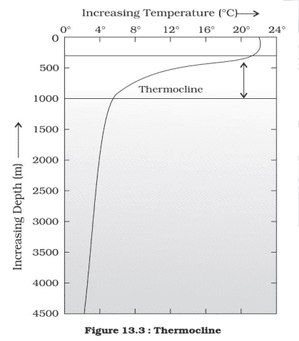
- The first layer is called Epilimnion (up to 200m)
- The second layer is called Thermocline (or Metalimnion) (200-1000m)
- The third layer is called Hypolimnion (beyond 1000m)
- Epilimnion:
- It extends up to 200m in depth.
- The average temperature is between 20-25 degrees celsius.
- It is a zone of constant sunlight and mixing due to winds.
- It is a zone of uniform temperature.
- It is the zone of Life
- Thermocline:
- It is the twilight zone, because of the very low amount of sunlight.
- The temperature decreases rapidly with depth.
- Hypolimnion:
- It is a zone of uniform and very cold temperatures.
- The average temperature is nearly 4 degrees Celsius
- It is because seawater attains maximum density at 4 degrees Celsius.
- It is also known as a dark zone.
- Horizontal Distribution
- The surface temperature lies between 20-25 degrees Celsius in tropical regions and decreases gradually towards the polar region.
- The three distinctive layers are visible along tropical regions.
- However, along polar regions, there will be a single uniform layer of cold temperature.
Salinity (7:50 PM)
- Salinity is the number of grams of dissolved salts in a thousand grams of seawater.
- It is measured as parts per thousand (ppt).
- The average salinity of Earth's ocean is 35 ppt.
- Sources of salinity
- Sources of addition
- (a) Sediments brought by rivers, which get dissolved over a long period of life.
- (b) Volcanic eruptions along the oceanic floor
- (c) Evaporation in Ocean
- The salinity of oceans always remains constant.
- The factors increasing salinity are balanced by the factors decreasing salinity.
- Sources reducing salinity
- (a) Addition of river water
- (b) Rainfall
- (c) Ice melting
- (d) precipitation of salts along the oceanic floors.
- Dissolved salts in Sea Water (Decreasing Order): Chlorine, sodium, sulfate, magnesium, Calcium
The Topic for the Next class: Oceanography (continued)